Cyclone vs Hurricane: What's the Difference?
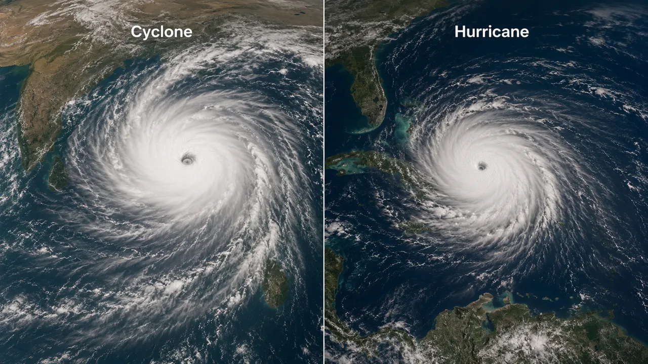
A storm with sustained winds over 200 km/h gets called a hurricane if it forms near Florida and a cyclone if it forms near Mumbai. Same storm, different name. The cyclone vs hurricane question comes down entirely to geography – both terms describe the same type of rotating tropical storm, and the difference between cyclone and hurricane is purely about which ocean it forms over.
Are Cyclones and Hurricanes the Same Thing?
Yes. Tropical cyclone is the umbrella scientific term – a circular storm system originating over warm tropical oceans, with low pressure, high winds, heavy rain, and a calm central eye. What is a cyclone vs hurricane then? Regional labels stacked on top of one universal phenomenon. The same storm is called a hurricane in the North Atlantic and eastern Pacific, a typhoon in Southeast Asia and China, and a tropical cyclone in the southwest Pacific and Indian Ocean.
Hurricane Katrina formed over the warm Gulf of Mexico in 2005 and devastated the US coast under that name. If an identical storm – same wind speeds, same structure – had formed instead over the Bay of Bengal, meteorologists would have called it a cyclone from day one. Nothing about the storm itself would differ.
Cyclone vs Hurricane: What Changes by Region
The ocean basin decides the name, not storm intensity or structure. The difference between hurricane and cyclone in practice is a line drawn on a map by meteorological convention, not by physics.
Where Hurricanes Form
The North Atlantic and Northeast Pacific – east of the International Date Line – are hurricane territory. Storms spinning up in the Gulf of Mexico, the Caribbean, or off the US East Coast all carry that name through their lifecycle. Tropical cyclones form near the equator, gaining energy from heat released as water vapour condenses into rain – the Atlantic basin has tracked these systems in detail since 1851, giving the US National Hurricane Center one of the longest continuous storm records anywhere.
Where Cyclones Form
Cross into the Indian Ocean or South Pacific, and the same storm becomes a cyclone. The southwest Pacific and Indian Ocean region uses this term specifically, covering everything from the Bay of Bengal to the waters off northern Australia and the Mozambique Channel. The naming itself is a coordinated effort – 13 countries bordering the north Indian Ocean, including Bangladesh, India, Sri Lanka, Thailand, and Yemen, each contribute names to a shared rotating list managed by India's Meteorological Department. Once a name is used, it's retired permanently – no repeats.
Track active tropical storms and live forecasts by region on MeteoFlow.
Do They Rotate in Different Directions?
Yes – and the split runs along the equator, not the storm-naming boundary. Hurricanes and cyclones in the Northern Hemisphere spin counter-clockwise. South of the equator, every cyclone spins clockwise. The Coriolis effect – Earth's rotation deflecting moving air – flips direction depending on which hemisphere a storm forms in.
That flip is also why no storm has ever been documented crossing the equator intact. The Coriolis force doesn't just weaken near the equator – it reverses signs entirely. A storm approaching that line loses the rotational push keeping it organized, and it dissipates rather than continuing on as a single spinning system into the opposite hemisphere.
How Are These Storms Measured and Categorised?
Wind speed drives every classification system, but the scale changes by region – which is the real answer to what's the difference between a cyclone and a hurricane once you get past naming. Atlantic and Pacific hurricanes use the Saffir-Simpson scale, Category 1 through 5, starting at 119 km/h sustained winds.
The Indian Ocean and South Pacific use different thresholds entirely. India's Meteorological Department classifies storms once sustained winds reach 62 km/h, working through stages including Cyclonic Storm, Severe Cyclonic Storm, and Super Cyclonic Storm. A storm labeled a Severe Cyclonic Storm in the Bay of Bengal and a Category 2 hurricane in the Atlantic can carry near-identical wind speeds – the category numbers themselves aren't built on the same scale, so they don't translate directly across basins.
Use MeteoFlow to monitor tropical storm activity, wind forecasts, and changing weather conditions in your region.
FAQ
Can a hurricane become a cyclone if it crosses into another ocean basin?
In principle, yes – a storm crossing from a hurricane basin into cyclone-naming waters would be renamed under the new region's convention. In practice this is rare, since most storms weaken or dissipate well before reaching another basin's boundary.
What happens to a storm's name when it crosses a regional boundary?
The storm gets renamed according to the system used in its new basin. This has happened with Pacific storms crossing the International Date Line, where they shift from hurricane status into the typhoon naming system used across the western Pacific.
Which ocean basin sees the most tropical storms each year?
The Northwest Pacific typhoon basin consistently produces the highest count, typically 25 to 30 named storms annually – more than the Atlantic and North Indian Ocean basins combined in a typical season.
Are storms getting stronger due to climate change?
Research from NOAA and peer-reviewed climate studies links rising sea surface temperatures to a higher proportion of storms reaching major hurricane or cyclone intensity. Trends in total storm count each year remain less conclusive across the research.
What is the eye of a storm and why is it calm?
The eye is a central region of clear skies, warm temperatures, and low atmospheric pressure – descending air there suppresses cloud formation. The surrounding eyewall carries the storm's strongest winds, creating a stark contrast between the violent ring and the calm center.


