Types of Rainfall: How Different Rain Formation Processes Work
Rainfall can be classified into three main types based on one shared mechanism: rising air. When air rises, it cools, moisture condenses, and precipitation forms. What differs between types of rainfall is what forces that air upward – surface heat, terrain, or the boundary between air masses.
Convectional, relief, and frontal rainfall each follow a distinct process and occur in different geographic conditions. Understanding these different types of rainfall explains why some regions receive intense afternoon downpours, others get steady days-long rain, and some mountain slopes stay wet while the land directly behind them stays dry.
What Are the Types of Rainfall
The same question – why is it raining? – can have three different answers depending on where you are and what the atmosphere is doing. Classifying types of rain by their formation mechanism gives a more useful answer than simply describing what falls from the sky.
How Rain Forms in the Atmosphere
Before any precipitation reaches the ground, air must rise and cool to its dew point – the temperature at which it can no longer hold moisture as vapor. At that point, water vapor condenses around small particles in the atmosphere, forming droplets. When those droplets grow heavy enough, they fall.
The uplift is the critical step. Without rising air, the atmosphere holds its moisture and no rain forms. What triggers that uplift – and how fast and high the air rises – determines the character of the rainfall that follows.
Why Meteorologists Classify Rainfall Types
The uplift mechanism determines where rain falls, how long it lasts, and how intense it gets. A classification based on the formation process is more geographically predictable than one based on appearance alone.
The same location can experience all three types of rainfall within a single week. A frontal system brings steady overnight rain, a mountain range forces additional precipitation from passing air, and afternoon heat generates a convective storm by the following day. Each requires a different forecast approach.
Convectional Rainfall
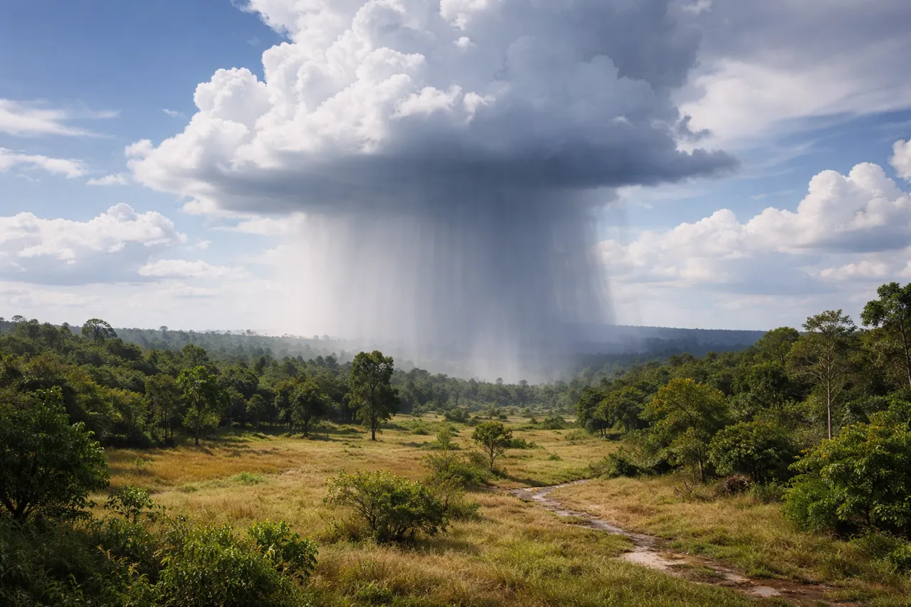
When the ground heats unevenly under strong sunshine, the air above it behaves differently from one patch of surface to the next. That uneven heating is what drives convectional rainfall – one of the most intense and geographically predictable types of rainfall in the world.
Convectional Rainfall Definition
The convectional rainfall definition starts at the surface. Solar radiation heats the ground, which warms the air directly above it. That warm air becomes less dense than the surrounding atmosphere and rises rapidly. As it climbs, it cools, reaches its dew point, and releases moisture – often producing cumulonimbus clouds and heavy rain within hours of the initial heating.
The process is fast and concentrated. Convectional rain typically falls in under an hour but can deliver 20-30 mm in that time. Thunder and lightning frequently accompany it because the rapid vertical movement generates strong electrical charge separation inside the cloud.
Where Convectional Rainfall Is Most Common
The equatorial belt sees convectional rainfall almost daily during wet season months. The Amazon basin, central Africa, and much of Southeast Asia receive this pattern consistently – surface temperatures stay high year-round, and moisture supply from vegetation and water bodies remains constant.
Continental interiors at mid-latitudes also experience convectional rain, but seasonally. In central Europe and the interior United States, summer afternoons regularly produce convective storms as land surfaces heat rapidly under clear morning skies and unstable air builds through the day.
The Congo Basin reinforces this pattern. It receives convectional rainfall on around 160 days per year – more than most other regions at the same latitude – because dense forest cover releases moisture continuously back into the atmosphere, feeding the cycle that drives the next day's storms.
Relief Rainfall (Orographic Rainfall)
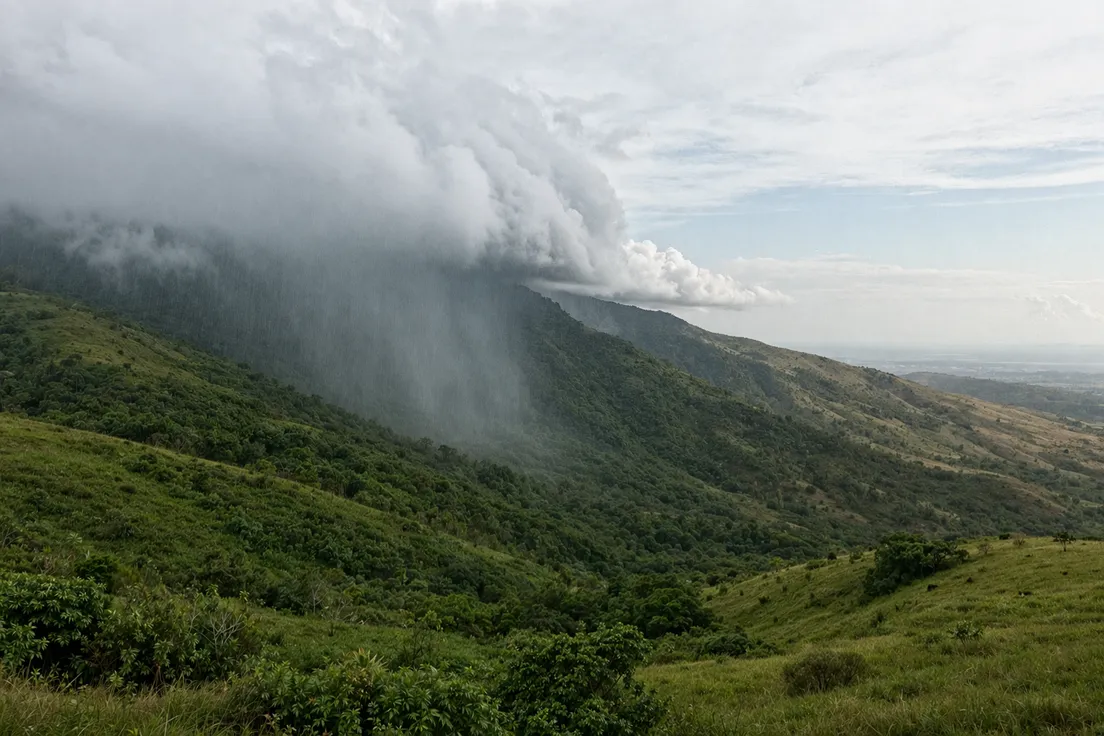
Terrain forces air to move in ways that flat surfaces never do. When moist air meets a mountain range, it has one option: go up. That forced ascent is the entire mechanism behind relief rainfall – and it produces some of the most pronounced precipitation patterns on Earth.
How Mountains Create Relief Rainfall
Moist air approaching a mountain range is pushed upward along the windward slope. As it rises, it cools at a consistent rate – roughly 6.5°C per kilometer of altitude. Once it reaches its dew point, condensation begins, clouds form, and precipitation falls on the windward side.
The windward slope of a mountain range can receive three to four times more annual rainfall than the leeward side. A diagram of relief rainfall typically shows this asymmetry clearly – heavy precipitation on one face, dry conditions on the other. The Western Ghats in India and the Southern Alps in New Zealand both demonstrate this pattern at a large scale.
Cherrapunji in northeastern India sits on the windward edge of the Khasi Hills, directly in the path of moisture-laden air moving inland from the Bay of Bengal. It historically recorded around 11,430 mm of rainfall per year – one of the highest annual totals on Earth, produced almost entirely by orographic uplift.
Rain Shadow Effect
On the leeward side, the process reverses. Air descends, and as it drops in altitude it warms through adiabatic compression. Warmer air holds more moisture, so instead of releasing precipitation it absorbs it. Cloud cover dissipates and conditions turn dry.
The Atacama Desert in Chile sits directly in the rain shadow of the Andes. It is one of the driest places on Earth – some weather stations there have recorded no rainfall for decades. The mountains that generate heavy precipitation on their western slopes create near-total aridity on the eastern side.
Frontal Rainfall (Cyclonic Rainfall)
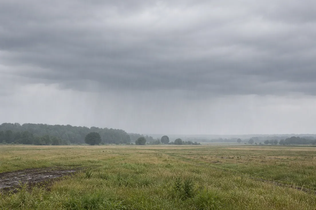
When two air masses with different temperatures meet, neither passes through the other. The warmer, less dense air rises over the cooler air beneath it. That boundary – and the rainfall it generates – is what defines frontal rainfall, also called cyclonic rainfall when associated with low-pressure systems.
How Warm and Cold Air Masses Interact
Warm air advancing over a cold air mass rises gradually along a shallow angle. The ascent is slow compared to convectional uplift, but it covers enormous horizontal distances. A warm front can produce rainfall across 300-500 km ahead of the surface boundary – a band of cloud and precipitation that arrives hours before the front itself reaches a given location.
The temperature contrast between the two air masses drives the process. The greater the difference, the more unstable the boundary and the more active the associated rainfall.
Weather Patterns Associated with Frontal Rain
Frontal rainfall is typically prolonged and covers wide areas at moderate intensity. A frontal system moving across northwestern Europe can bring continuous rain for 12-24 hours across several countries simultaneously. That duration and spatial extent distinguishes it clearly from convectional bursts.
Most rainfall in the UK and northwestern Europe is frontal in origin, driven by Atlantic low-pressure systems tracking eastward. Cyclonic rainfall of this type dominates the region's climate because warm Atlantic air and cooler continental or polar air meet repeatedly along the same general track through autumn and winter.
Check current precipitation conditions and cloud cover on MeteoFlow to see what type of rainfall may be approaching your location today.
Other Ways Rainfall Is Classified
The formation mechanism explains why rain falls where it does. But rainfall is also classified by what falls and how much of it arrives per hour. These secondary systems give a more complete picture of different types of rainfall beyond the three main formation categories.
Rainfall by Intensity
Meteorologists measure rainfall intensity in millimeters per hour. Light rain sits below 2.5 mm per hour – enough to wet surfaces gradually. Moderate rain falls between 2.5 and 7.6 mm per hour. Above 7.6 mm per hour is classified as heavy rain, and anything exceeding 50 mm per hour is considered extreme.
Drizzle sits outside the standard rain categories entirely. Droplets are smaller than 0.5 mm in diameter and fall slowly from low stratus clouds. It rarely registers as significant in hourly totals but reduces visibility and saturates surfaces over time.
Tropical cyclones illustrate the upper end of that scale directly. During Hurricane Harvey in 2017, a weather station near Houston recorded 1,539 mm of rainfall over four days – an average hourly rate that repeatedly exceeded the extreme threshold for sustained periods, overwhelming drainage systems designed around normal heavy rain parameters.
Rainfall by Composition
Not all precipitation that falls as liquid has the same chemical or physical composition. Acid rain forms when sulfur dioxide and nitrogen oxides dissolve in atmospheric moisture, producing a solution with a pH below 5.6. It falls through the same mechanisms as ordinary rain but carries different environmental consequences.
Freezing rain and mixed precipitation are composition-based classifications too. Freezing rain reaches the surface as liquid and solidifies on contact with cold objects. It forms through a different vertical temperature profile than snow or sleet, and its effects on surfaces are distinct from either.
Check rainfall forecasts and current weather conditions on MeteoFlow to track precipitation in your area and plan around incoming rain.
FAQ
Which type of rainfall produces the heaviest rain?
Convectional rainfall delivers the highest intensity. The rapid vertical uplift generates deep cumulonimbus clouds capable of releasing 20-30 mm in under an hour. Frontal and relief rainfall tend to be more prolonged but rarely match convectional rain at peak intensity.
Where is convectional rainfall most common in the world?
Equatorial regions see it most consistently – the Amazon basin, central Africa, and Southeast Asia receive convectional types of rain almost daily during wet season months. At mid-latitudes, it appears seasonally in continental interiors during summer afternoons when land surfaces heat rapidly.
What causes rain shadows in mountainous regions?
As air descends on the leeward side of a mountain range, it warms through adiabatic compression and its capacity to hold moisture increases. Precipitation stops and cloud cover clears. This is the direct consequence of relief rainfall releasing moisture on the windward slope – the descending air arrives dry.
Can several rainfall processes happen during the same storm?
Yes. A frontal system tracking over a mountain range combines frontal and relief mechanisms simultaneously – the air mass boundary drives widespread uplift while terrain forces additional ascent on windward slopes. Convectional activity can develop within the same system if surface heating is strong enough.