Types of Weather: A Guide to Different Weather Conditions
The weather you experience on any given day falls into one of several recognizable conditions – sun, cloud, rain, snow, wind, fog, or storm. These are the main types of weather that shape daily life, travel, and outdoor activity across the world. Each condition has a distinct cause and a distinct set of characteristics.
Different types of weather occur because the atmosphere is constantly in motion. Temperature, moisture, and air pressure shift continuously, and the combinations they produce vary from clear skies to severe storms. Understanding what drives each condition makes forecasts easier to read and weather easier to anticipate.
What Are Types of Weather
All weather begins with the same three variables: temperature, air pressure, and moisture. Types of weather are essentially the visible and measurable results of how those variables interact at a given place and time. The same atmosphere that produces a clear summer morning can generate a thunderstorm by afternoon.
How Weather Conditions Form in the Atmosphere
Nearly all weather forms in the troposphere – the atmospheric layer that extends roughly 12 km above the surface. Temperature drops steadily with altitude there, moisture condenses into clouds, and pressure systems build and shift. Everything that shows up in a forecast originates in this narrow band of air above the ground.
When warm, moist air rises, it cools and releases moisture as precipitation. When dry, high-pressure air settles, it suppresses cloud formation and produces clear conditions. Different weather conditions are the result of these processes playing out at different intensities and locations.
Why Weather Changes from Day to Day
Air masses – large bodies of air with consistent temperature and humidity – move across the surface and interact at boundaries called fronts. When a cold air mass meets a warmer one, the warmer air is forced upward. That uplift produces clouds, wind shifts, and often precipitation.
A single frontal passage can drop temperatures by 15°C within a few hours. This is why conditions can shift from mild and sunny to cold and rainy within the same day, without any dramatic event triggering the change.
Main Types of Weather Conditions
Weather conditions vary widely, but most people encounter the same core types repeatedly. The different types of weather below cover the conditions that appear most frequently in forecasts and daily experience. Meteorologists use specific weather names to classify each one based on measurable atmospheric characteristics.
Sunny and Clear Weather
Clear weather develops under high-pressure systems, where descending air suppresses cloud formation. Skies stay open, humidity stays low, and solar radiation reaches the surface with little interference.
One detail worth knowing: high-pressure systems produce clear conditions in both summer and winter. In winter, the same cloudless sky that brings bright sunshine also allows heat to escape overnight, leading to sharp overnight frosts. Clear does not always mean warm.
Cloudy and Overcast Weather
Stratus clouds sit low, spread flat across the sky, and can hold for days without releasing a drop of rain. That persistence is what separates overcast conditions from the kind of cloud cover that precedes a storm – the sky looks similar, but the atmosphere behaves differently.
Prolonged overcast reduces surface temperatures and keeps humidity high at ground level. A week of grey skies with no precipitation still leaves soil moisture elevated and overnight lows warmer than they would be under a clear, radiating sky.
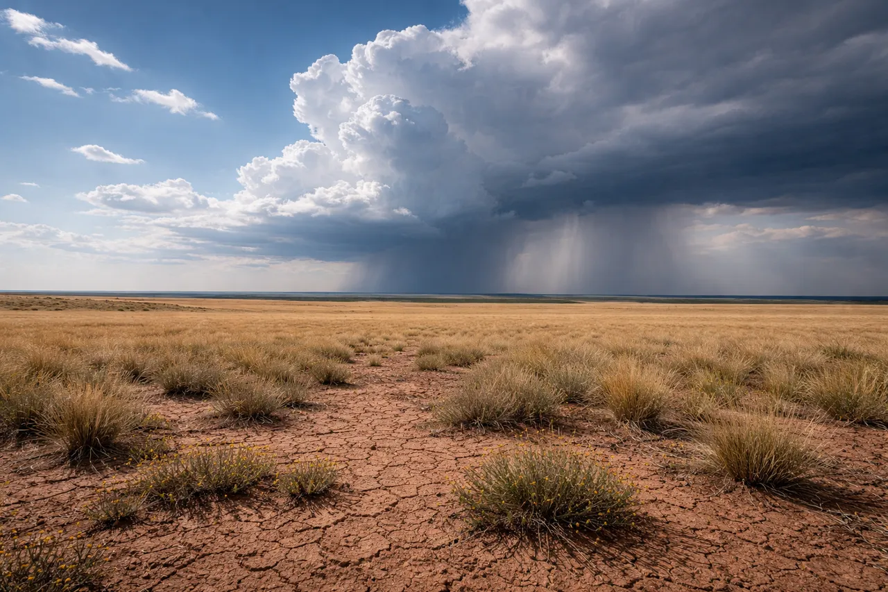
Rainy Weather
Rainfall intensity varies considerably – drizzle, steady rain, and heavy downpours are distinct conditions with different causes and different impacts. Drizzle falls from low stratus clouds with minimal updraft activity. Heavy rain typically requires deeper convective systems with stronger vertical motion.
The wettest inhabited location on Earth, Mawsynram in northeastern India, receives over 11,000 mm of rainfall annually. Most mid-latitude cities receive between 500 and 900 mm per year. That range illustrates how dramatically different types of weather patterns vary by geography and season.
Snowy and Freezing Weather
Snow forms when atmospheric temperatures are low enough for water vapor to crystallize before reaching the ground. It can fall at temperatures slightly above 0°C if the air is dry enough – moisture content affects the freezing threshold.
Freezing rain is a distinct condition, separate from snow. It occurs when precipitation falls as liquid but freezes on contact with surfaces that are below 0°C. The result is an ice layer rather than a snow layer, and it creates significantly different hazards.
Wind and Atmospheric Movement
Not all different weather conditions involve precipitation. Wind and fog are two of the most practically significant atmospheric states – one affects everything from transport to structural safety, the other reduces visibility to the point where movement becomes dangerous.
Windy Weather
Wind is air moving from areas of high pressure toward areas of low pressure. The greater the pressure difference, the faster the air moves. At surface level, this produces everything from a light breeze to storm-force gusts capable of structural damage.
At force 2, leaves rustle and you feel wind on your face. At force 7, walking into it takes effort. The Beaufort scale captures that entire range in 13 steps, from dead calm at 0 to sustained winds above 118 km/h at force 12. Daily forecasts rarely mention the scale by name, but the conditions it describes are what most people experience as anything from a pleasant breeze to a day when it is better to stay indoors.
Fog and Low Visibility Conditions
Fog forms when air cools to its dew point near the surface and water vapor condenses into suspended droplets. It is essentially a cloud at ground level, with the same physical composition but a different formation mechanism.
Meteorologically, fog is defined by visibility below 1 km. Mist sits between 1 and 2 km. That distinction matters practically – fog triggers transport warnings and airfield closures that mist does not. Radiation fog, which forms on clear, calm nights as the surface loses heat, is the most common type in inland areas during autumn and winter.
Severe Weather Events
Most weather events fall within a predictable range of conditions. Severe weather sits outside that range – it develops faster, reaches greater intensity, and carries direct risks to safety and infrastructure. The three categories below account for the majority of weather-related damage globally.
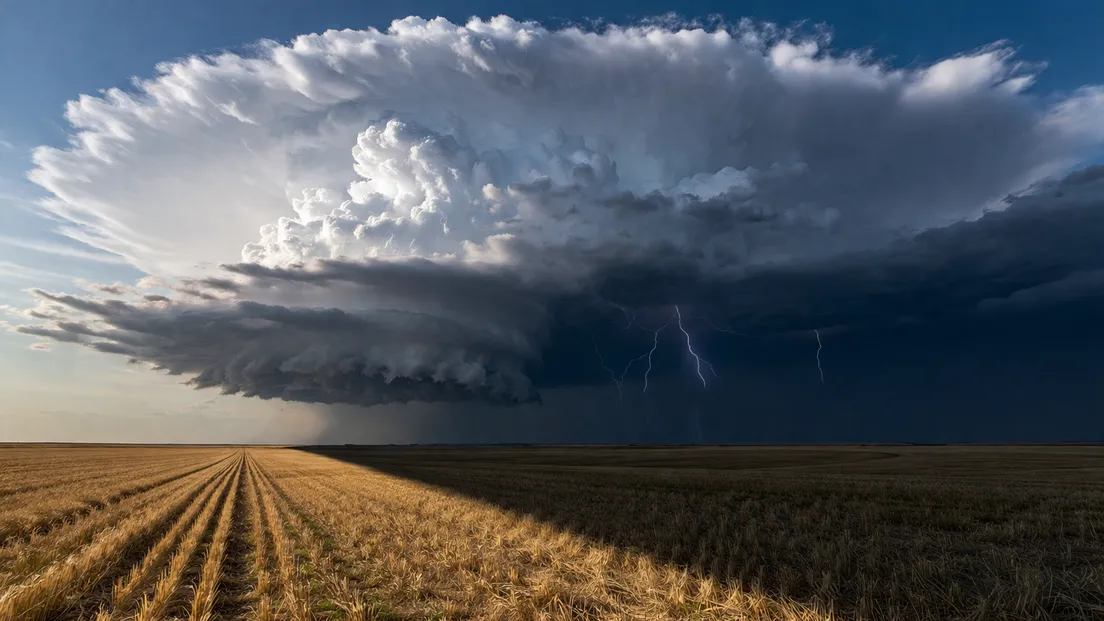
Thunderstorms and Lightning
Thunderstorms develop inside cumulonimbus clouds – tall, dense formations that extend from low altitudes up to the tropopause. Strong updrafts carry moisture upward rapidly, where it freezes and creates electrical charge separation between the upper and lower parts of the cloud.
Around 40,000 thunderstorms occur on Earth every day. They are the most frequent severe weather events globally, and they produce not just lightning but heavy rain, hail, and sometimes tornadoes. Most last between 30 minutes and an hour, though organized storm systems can persist for much longer.
Tornadoes and Hurricanes
Both involve rotating wind systems, but they differ fundamentally in scale, origin, and duration. Tornadoes are narrow, violent columns of rotating air that extend from a thunderstorm to the ground. They typically last minutes, sometimes less, but wind speeds can exceed 400 km/h in the most extreme cases.
Hurricanes – also called typhoons or cyclones depending on the region – form over warm ocean water and can sustain for days or weeks. They cover hundreds of kilometers and lose intensity only when they move over land or cooler water.
Blizzards and Severe Winter Weather
Heavy snowfall alone does not constitute a blizzard. A blizzard requires three simultaneous conditions: falling or blowing snow, winds above 56 km/h, and visibility below 400 meters. That combination makes movement dangerous and disorienting even in familiar terrain.
Severe winter weather also includes ice storms, where freezing rain accumulates on surfaces, and polar vortex disruptions, which push Arctic air into mid-latitude regions and produce sustained extreme cold well outside its normal geographic range.
Check MeteoFlow to see which type of weather is expected in your location today – before you travel, plan outdoor activity, or make decisions that depend on conditions.
Different Weather Phenomena Explained
Precipitation comes in more forms than rain and snow. Several weather phenomenon types that people encounter regularly are often confused with each other because they look similar at ground level but form through different atmospheric processes.
Rain, Drizzle, and Showers
The difference between these three comes down to droplet size and formation mechanism. Drizzle consists of droplets smaller than 0.5 mm in diameter, falling slowly from low stratus clouds with weak updraft activity. Rain droplets range up to 5 mm and fall from deeper cloud systems with stronger vertical development.
Showers are convective – they form when warm air rises rapidly, cools, and releases moisture in short, intense bursts. A shower can begin and end within minutes. Steady rain from a frontal system can persist for hours. Both are weather phenomenon types that appear similar from the ground but require different forecast interpretations.
Hail, Sleet, and Freezing Rain
All three involve frozen or partially frozen precipitation, but each forms differently. Hail develops inside thunderstorm updrafts, where ice pellets are carried repeatedly upward before falling. The strongest updrafts produce the largest hailstones – some reaching the size of a grapefruit and falling at speeds above 160 km/h.
Sleet forms when rain passes through a shallow layer of freezing air near the surface and partially freezes before landing. Freezing rain stays liquid longer and freezes only on contact with cold surfaces, creating a smooth ice layer. That ice accumulation is often more hazardous than either snow or sleet because it is nearly invisible and forms rapidly.
Why Understanding Different Types of Weather Matters
Weather affects decisions made every day – what to wear, whether to drive, when to schedule outdoor work, how to prepare a home for an incoming storm. Most of those decisions improve when the conditions involved are understood rather than just observed.
Severe weather events carry direct safety implications. A blizzard warning means something specific – not just snow, but reduced visibility and dangerous wind. A thunderstorm forecast over a mountain route is different information from a light rain forecast. Knowing what each condition actually involves changes how people respond to it.
Agriculture, construction, aviation, and energy supply all operate around weather in ways that affect daily life indirectly. A frost forecast that seems minor can determine whether a crop survives. A fog warning at an airport shifts dozens of flights. The practical reach of types of weather extends well beyond personal comfort.
Forecasts have become more accurate and more localized over the past two decades. Hourly condition data is now available for most populated areas. That precision is only useful if the person reading the forecast understands what the listed conditions actually mean on the ground.
Use MeteoFlow to check the forecast and understand upcoming weather events and conditions in your area before they arrive.
FAQ
How many types of weather are there?
There is no fixed universal number. Meteorologists classify conditions by measurable variables rather than a set list. In everyday terms, most people recognize six to ten distinct conditions – sun, cloud, rain, snow, wind, fog, storm, and variations within each category such as drizzle, sleet, or blizzard.
What is the difference between weather and climate?
Weather refers to atmospheric conditions at a specific place and time – what is happening outside today. Climate is the long-term average of those conditions over decades. A single cold summer does not change a region's climate, but it is a weather event.
What are the most common weather phenomena around the world?
Rain and wind are the most widespread weather phenomenon types globally. Cloud cover and fog affect large portions of the planet daily. Thunderstorms, while intense, are also extremely frequent – occurring tens of thousands of times per day across all continents.
How do meteorologists classify weather conditions?
Through measurable atmospheric variables: temperature, air pressure, humidity, wind speed, wind direction, and precipitation type and intensity. These readings, combined with satellite and radar data, allow conditions to be identified and forecast with increasing precision.
Can multiple types of weather happen at the same time?
Yes. Different types of weather can and do occur simultaneously. Freezing rain can fall during strong wind. Snow can occur alongside thunder – a phenomenon called thundersnow, which happens when convective activity is strong enough to produce lightning within a snowstorm.